
Atlas in the Field, Part 1: Interview with Mike Markovina, WCS-Tanzania
June 23rd, 2020This is Part 1 of a 2-part blog series of Atlas In the Field, Eastern Africa edition. Look for Part 2 where we interview CORDIO and some of their collaborators about their data collection work.
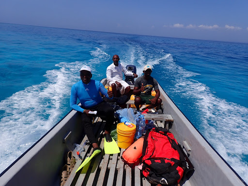
One of the most important and time-consuming parts of creating the Allen Coral Atlas is the collection of field data to calibrate and validate the maps. This ground-truthing step is essential for training our machine learning algorithm that generates the benthic data layers, which then characterize the shallow sea floor. While some of these data are sourced through our network of coral reef managers and researchers who have generously shared their data sets, the Atlas team also depends on field teams in different regions to collect new data.
(Photo by Michael Markovina, 2020)
Earlier this spring we (Brianna Bambic, program manager, and Zoë Lieb, project coordinator of the National Geographic Society) had the chance to interview Mike Markovina, director of the Marine Program for Wildlife Conservation Society (WCS) Tanzania (responses have been edited slightly for clarity). A highly experienced fisheries scientist, Mike works extensively in East Africa on the topic of illegal fisheries, as well as a range of other marine conservation issues.
Passionate about marine conservation, Mike told us about his 2019-2020 data collection expedition in Northern Tanzania and Kenya, supported by a grant from the Paul M. Angell Family Foundation. He shed some light on the experience of collecting Allen Coral Atlas coral reef data, the declining state of reefs in Eastern Africa, as well as the role of technology in marine conservation.
------------------------------------------------------------
Q: Did you see anything particularly cool or interesting on this field work trip?
I managed to go to locations I have never dived before, including East Pemba. I managed to do a deep dive after the survey in one location to 40 – 45 meters, and from the start of the coral slope at 10 meters to 45 (sandy ledge before a drop to 200), the reef was just completely covered in algae. It looked like an AstroTurf and there were no fish, despite what must have been the most incredible habitat. I also surveyed reefs in northern Tanga that were so destroyed, it was utterly depressing. I had a number of reality checks regarding the reef devastation I observed. I did manage to find an off-shore location with incredible corals, however, there were literally no fish.
(Photo by Michael Markovina, 2020)
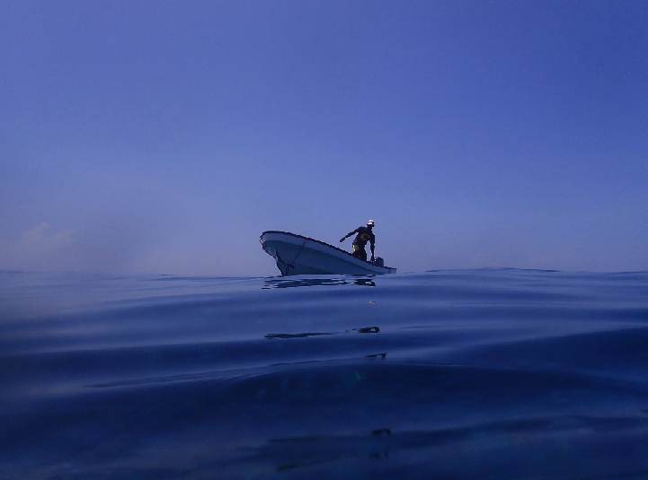
Q: Were there any unique firsts or data points you’d like to highlight (approx. how many dives, hours spent in the water, reefs surveyed)?
I did 75 transects, so about 30 – 35km of surveys. All my dives were freediving, so on a transect, I would average about 80 and 110 free dives (more if water was deeper). A transect would take approximately 24 – 28 minutes depending on wind, current, waves and surge. At an average of 25 minutes per transect for 75 transects, I spent 31.25 hours in water.
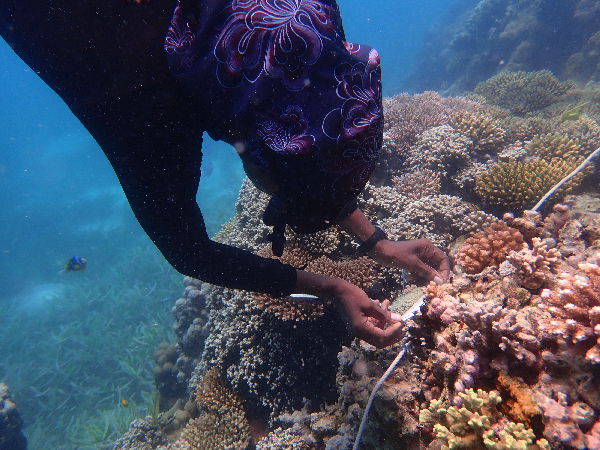
Diver surveying the reef in Tanzania. (Photo by Michael Markovina, 2020)
Q: What were the biggest challenges you faced on this specific trip, or on any field trip?
I had very few challenges, apart from wildly changing weather and lightning storms whilst in the water. Also jellyfish - I encountered a jellyfish bloom more vast and extensive than anything I have seen before.

Jellyfish surrounding research diver. (Photo by Michael Markovina, 2020)
Q: Tell us about the corals you surveyed. How would you describe it to someone who has never been?
To people who know and understand corals, it is more a process of enjoying time to yourself, and focusing on what you are seeing, as the Allen Coral Atlas gave us access to areas we don’t normally go due to project location restrictions that leave little to no room to explore. To someone who has never seen the reef, it is like looking at a city from a helicopter. Lots of activity, colour, shapes and the buildings teeming with life and activity inside. Also, when you look at a devastated reef, it looks like a bombed city in Syria. The very components that make you go “wow” at the sight of a beautiful functioning city are missing and lying in ruin. It is very impactful.

(Photo by Michael Markovina, 2020)
Q: Did you see any signs that the reefs were improving or degrading? What did these signs look like?
There are more signs of trouble than not. Reefs were reduced to rubble fields in many locations, fishing nets tangled in the reefs, broken coral bommies from fishing and anchors. Signs of paling, some bleached corals and massive coral beds completely inundated with algae, not just at the surface but at depth too.

Devastated reefs in northern Tanzania. (Photo by Michael Markovina, 2020)
Q: Did you use the Allen Coral Atlas in any unique ways?
Yes, I deliberately targeted areas that I have not been to either in a long time, or ever before. I used the opportunity to explore outer reefs, remote MPAs and points of interest. I ideally would like to continue this for longer and explore more areas.

Atlas satellite image north of Pemba, Tanzania. (Allen Coral Atlas, 2020)
Q: Do you have a specific success story you can share around the Allen Coral Atlas?
There is no measurable success story, however I did take a local Tanzanian youngster, who is passionate about educating the youth on corals. I took him to the locations in Zanzibar and Dar es Salaam, so he could see first-hand what corals looked like, the differences between healthy and poor health corals and also to learn about reef monitoring. He was completely absorbed in the experience and now uses his knowledge in his educational presentations.

Mike Markovina and Tanzanian youngster collecting data. (Photo by Michael Markovina, 2020)
Q: How do you see the role of tech in helping to protect the world’s coral reefs?
It is important; however, it must not be an excuse towards poor management (i.e. thinking tech will be the solution). It must also be at an appropriate scale, especially in countries with limited capacity. I think countries must improve their management first before the benefits of tech manifest themselves.

Atlas data collection. (Photo by Michael Markovina, 2020)
Q: What makes you most excited about the potential of tech in your work?
I enjoy tech, I enjoy exploring the boundaries of technology. I feel that modern conservation is depressing and pays a high emotional cost, tech offers a way to think creatively outside the box of classic donor-funded activities and repetitive government training.
Q: Why are you so passionate about coral reefs? Or, what do coral reefs mean to you?
It’s an essential marine habitat, and it fluoresces under black light, and we still know so little about coral reefs. The complexity in 1 square meter is astonishing, yet millions who depend on corals reefs will never learn that.
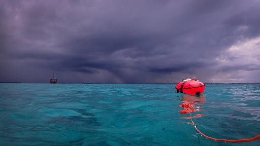
Atlas data collection before the storm. (Photo by Michael Markovina, 2020)
Q: What gives you hope for the future of coral reefs?
Honestly, very little. Maybe to be less melodramatic, I hope that the complexity and mystery of life itself will save coral reefs.
------------------------------------------------------------------------------
While there is still so much still to discover and admire about coral reefs, Mike highlights the all-too-common reality that these habitats are rapidly declining and facing more risks than ever before. He also emphasizes that while technology has an important role to play in conservation, it’s the effective application and scale of those tools that make for meaningful conservation.
This is something the Allen Coral Atlas team keeps as a top priority: while making a global map to inform coral reef conservation, we’re simultaneously aiming for a highly usable and accessible tool to make sure as many researchers, practitioners, and policymakers as possible can make use of the Atlas as a resource.
The datasets Mike and his team collected in Tanzania and Mozambique are going to crucially inform the mapping process of the Eastern Africa region of the Atlas. It’s field data like this that makes accurate machine learning mapping possible.
Collecting new data was already logistically challenging and expensive, and with the addition of the COVID-19 crisis, all fieldwork is essentially halted. This makes existing data all the more valuable to the Allen Coral Atlas. If you or your organization have georeferenced benthic data sets of shallow reef habitats or seagrass beds available, please get in touch with us at support@allencoralatlas.org. All individuals and organizations that provide data are attributed on our website for their contribution, the data itself will not be published so it still retains its novelty, and you will be contributing to a resource that benefits coral reef conservation around the world.